
Badlands Geology

The buttes around Medora are a stack of rock layers about 60 million years old, laid down by rivers, lakes and swamps just after the age of dinosaurs. Gray-brown bands are sandstone and clay, black seams are lignite coal, and the red caps are clinker, rock baked hard when coal seams burned underground. The Little Missouri River began carving those layers into badlands after Ice Age glaciers turned it east, at least 640,000 years ago.
Tap any spot in Theodore Roosevelt National Park on the map below, or use your location on the Scenic Loop Drive, to see which layer you are standing on and what to look for. The South Unit entrance is in Medora, a few minutes from the Library.
How the badlands formed
Every butte in the park tells the same story, one layer at a time.
Swamp forests, about 60 million years ago
With the dinosaurs gone and the Rocky Mountains rising to the west, rivers carried sand and mud east into a low, wet country of channels, lakes and swamps. That sediment became the yellowish Bullion Creek Formation and the gray-brown Sentinel Butte Formation above it. Conifers, probably relatives of today's bald cypress and redwoods, grew with their roots in standing water. Floods buried their stumps, which slowly turned to stone, and fallen plants piled up as peat that became lignite coal.
Ash from distant volcanoes
Eruptions more than 250 miles away dusted the region with ash. Washed into a lake, it became the blue-gray bentonite clay, with a white core of ash, that bands the North Unit. Bentonite swells when wet, cracks into a crunchy "popcorn" crust when dry, and turns slick after rain.
Glaciers turn the river
The Little Missouri once flowed north toward Hudson Bay. During the Ice Age, continental glaciers blocked that route, at least 640,000 years ago, and forced the river east onto a shorter, steeper path. A steeper river cuts faster, and it began slicing down through the soft layers. Its old floors survive as gravel benches 160 to 270 feet above the water, and granite boulders the ice left behind still sit near Sperati Point in the North Unit.
Fire in the ground
As erosion exposed coal seams to the air, some caught fire and smoldered for years. The heat baked the clay above into hard red clinker, called scoria locally though it is not volcanic. Because clinker resists erosion, it caps ridges across the park. The most recent large burn, near Buck Hill in the South Unit, smoldered from 1951 to 1977; Coal Vein Trail walks through it.
Still being made
The badlands are not finished. Hillsides slump after wet springs, some North Unit blocks having dropped about 120 feet in one piece, and the sand on today's valley floors is less than 500 years old.
Read the layers
Tap a layer to read its chapter, oldest at the bottom.
Where to see the geology
These pullouts and trails put the geology front and center. Each link opens the stop on the geology map.
South Unit (Medora)
- Skyline Vista: a gravel bench left by the Little Missouri during the Ice Age, about 260 feet above the river.
- Scoria Point Overlook: yellowish Bullion Creek layers below, a red clinker band, gray-brown Sentinel Butte layers above.
- Coal Vein Trail: ground that slumped as a coal seam burned beneath it from 1951 to 1977.
- Painted Canyon Visitor Center, off I-94 about seven miles east of Medora: the classic panorama of gray-brown layers, black coal seams and red clinker, with petrified stumps in the slopes nearby.
- Petrified Forest Plateau: upright petrified stumps up to about six feet tall. The National Park Service says the park has the third-highest concentration of petrified wood in the United States. A long hike on the park's west side.
North Unit (near Watford City)
- Slump Block Pullout: giant blocks of layered rock tilted back into the hillside.
- Cannonball Concretions Pullout: round sandstone concretions weathering out of softer rock.
- Oxbow Overlook: the blue bentonite band and a huge landslide below the river bend the glaciers helped create.
Collecting rocks, fossils or petrified wood is illegal in the park. For road and trail status, check park conditions. Plan the rest of your day with the national park guide, hiking near Medora and Wildlife Watch.
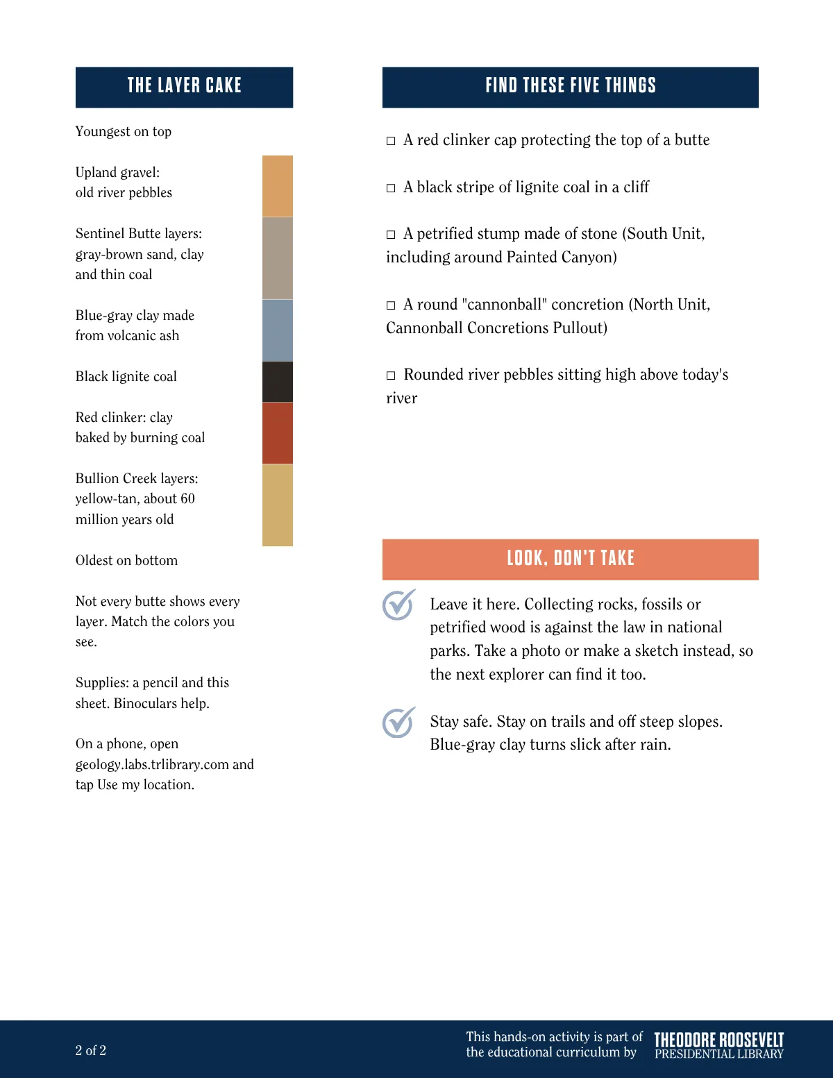
Print the Read the Rocks field sheet for students before your visit. It has a color-coded layer column for naming the bands in the buttes, a "find these five things" checklist for the drive and the park's no-collecting rule. It is one of the Library's Hands-On History activities for educators.
The scenery is often exceedingly striking in character, especially in the Bad Lands, with their queer fantastic formations. Among the most interesting features are the burning mines. These are formed by the coal seams that get on fire.
Badlands geology: common questions
The rock layers are about 60 million years old, from the Paleocene epoch just after the age of dinosaurs. The badlands landscape is much younger. The Little Missouri River began carving it after Ice Age glaciers turned the river east, at least 640,000 years ago, and the carving continues today.
Clinker, called scoria locally. It forms when a lignite coal seam catches fire underground and bakes the clay and sand above it like brick. It is not volcanic. The most recent large burn, near Buck Hill in the South Unit of Theodore Roosevelt National Park, smoldered from 1951 to 1977. Coal Vein Trail walks through it.
Bentonite, a clay made from volcanic ash that drifted in from eruptions more than 250 miles away. A white band of ash runs through the middle of it. It is easiest to see between Oxbow Overlook and River Bend Overlook on the North Unit Scenic Drive. Bentonite turns slick when wet, so stay off it after rain.
Theodore Roosevelt National Park has the third-highest concentration of petrified wood in the United States, according to the National Park Service. Upright stumps are scattered across the South Unit, including around Painted Canyon. The largest concentration is on the Petrified Forest Plateau, reached by a long hike from the Petrified Forest trailhead, about 50 minutes from Medora on dirt and gravel roads. Collecting is illegal in the park.
Concretions: balls of sandstone cemented hard by minerals underground. When the softer sand around them washes away, the round "cannonballs" are left behind. See them at the Cannonball Concretions Pullout on the North Unit Scenic Drive, south of Watford City.
Yes. Open geology.labs.trlibrary.com and tap Use my location. It runs in the browser with nothing to download, and the card updates as you cross from one rock layer into the next. Cell coverage is limited in parts of the park, so open the page before you lose signal.
More ways to explore the Badlands

Wildlife Watching
Bison, wild horses and elk: what to look for, where to find them and when to go.

Camping Near Medora
Free camping on public land, park campgrounds and how to tell public land from private.

Elkhorn Ranch
Directions, road conditions and a stop-by-stop walk at the site of Roosevelt’s home ranch.

Northern Lights in Medora
A live aurora outlook and the best nights ahead to see the lights over the Badlands.